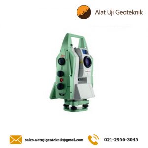
Leica FlexLine TS10

Description

Leica FlexLine TS10 is a high-end manual total station, enabling you to carry out high-demand survey tasks with Leica Captivate software. This way you can participate in the world of 3D by benefiting from 3D views of your measured data.

The TS10 solves daily professional challenges and tasks for growing demands within surveying and mapping, building construction and civil engineering:

  • Managing directors of construction departments benefit from minimal downtime of your survey crews to deliver projects under budget and in time.
  • Survey managers can rely on the highest product durability in the market, which increases your planning certainty.
  • Surveyors work faster by measuring more points per day with less measurement errors and rework.

Leica FlexLine: The new generation of manual total stations
The new Leica FlexLine series is based on a proven product concept, revolutionising the world of measurement and survey for nearly 200 years. Unlike any other manual total stations in the market, Leica Geosystems manual total stations focus on providing the highest quality, the lowest total cost of ownership and the longest durability in the industry, enabling users to work with purpose-driven solutions for the best performance results.

AutoHeight: Revolutionising instrument height measurement
The TS10 offers the world’s first AutoHeight feature as an option. AutoHeight enables the instrument to automatically measure, read and set its instrument height. Prevent time consuming manual effort and eliminate critical errors during the instrument setup when this revolutionary feature uses a laser from the instrument to measure to the ground and automatically passes the measurement to the software.

Leica Captivate software: Comprehensive, intuitive and easy to use
The TS10 is equipped with the Leica Captivate field software, a comprehensive application-based software package. This intuitive, familiar software helps you to capture even more points than before. You are also able to tie into the modern 3D dataflow and rigorous quality assurance and control routines.

Service and support: Global, local and best-in-class
Now with optional mobile internet access the TS10 connects to the office for a seamless dataflow and to Leica Geosystems trusted global service and support at the touch of a button. With the Active Customer Care program and myWorld customer portal, users have access to latest software updates, service and support as well as to mySecurity. With mySecurity activated, the locking mechanism ensures the device is disabled and can no longer be used.

Spesification

 = Include ,  = Not Available , • = Optional

 ANGULAR MEASUREMENT
 Accuracy Hz and V  Absolute, continuous, diametrical1 1’’ / 2’’ / 3’’ / 5’’
 
  • Display resolution: 0.1’’ (0.1 mgon)
  • Quadruple axis compensation
  • Compensator setting accuracy2: 0.5’’ / 1’’/ 1.5’’
  • Compensator range: +/- 4’
  • Electronic level resolution: 2“
  • Circular level sensitivity: 6` / 2 mm
 DISTANCE MEASUREMENT
 Range
  • Prism (GPR1, GPH1P): 1.5 m to 3.500 m
  • Prism GPR1 (Long Range mode) > 10.000 m


 Non-Prism / Any surface

  • R5003
  • R10004
 

 Accuracy /

Measurement time

 Single prism

  • Precise+ / Once: 1 mm + 1.5 ppm (typical 2.4 s)
  • Once&Fast: 2 mm + 1.5 ppm (typical 2 s)
  • Continously: 3 mm + 1.5 ppm (typical < 0.15 s)
  • Averaging: 1 mm + 1.5 ppm
  • Long Range mode / > 4 km: 5 mm + 2 ppm (typical 2.5 s)


 Non-Prism / Any surface

  • 0 m – 500 m: 2 mm + 2 ppm (typical 3 – 6 s)
  • > 500 m: 4 mm + 2 ppm (typical 3 – 6 s)


 Laser dot size
  • At 30 m: 7 mm x 10 mm
  • At 50 m: 8 mm x 20 mm
  • At 100 m: 16 mm x 25 mm
 
 Telescope
  • Magnification: 30x
  • Resolving power: 3”
  • Focusing range: 1.55 m / 5.08 ft to infinity
  • Field of view: 1°30’ / 1.66 gon / 2.7 m at 100 m


 GENERAL
 Display and keyboard  5“ (inch), 800 x 480 pixels WVGA, colour and touch

  • 25 keys5a
  • 37 keys with function keys5b


 2nd keyboard
 Key illumination
 Operation
  • Endless drives for HZ & V
  • Trigger-Key: user definable with 2 functions


 Power management  Exchangeable Lithium-Ion battery6

  • Operating time with GEB361
  • Operating time with GEB331
up to 18 h

up to 9 h

 Battery charging time with

  • GKL341 charger for GEB361 / GEB331
  • GKL311 charger for GEB361 / GEB331
 

3 h 30 min / 3 h

6 h 30 min / 3 h 30 min

 External supply voltage

  • Nominal voltage 13.0 V DC & 16 W max
 Data storage
  • Internal memory: 2 GB Flash
  • Memory card: SD card 1 GB or 8 GB
  • USB memory stick: 1 GB
 
 Processor
  • TI OMAP4430 1GHz Dual-core ARM® Cortex™ A9 MPCore™
  • Operating system – Windows EC7
  
 Interfaces  RS2327, USB device

 Bluetooth®8, WLAN9

 Mobile Data sidecover: LTE-Modem for internet access


 Guide Light (EGL)
  • Working range: 5 m to 150 m
  • Position accuracy: 5 cm at 100 m
  • Wavelength red /orange: 617 nm / 593 nm

(R1000)

 Laser plummet

(Laserclass 2)

 Accuracy

  • Plumb line deviation: 1.5 mm at 1.5 m instrument height
  • Diameter of laser point: 2.5 mm at 1.5 m instrument height


 AutoHeight module for automatic

instrument height measurement

(Laserclass 2)

 Accuracy

  • Distance accuracy: 1.0 mm (1 Sigma)
  • Distance range: 0.7 m to 2.7 m
 
 Weight    4.4 – 4.9 kg
 Environmental

specifications10

  • Working temperature range: –20°C to +50°C
  • Arctic version: –35°C to +50°C
  • Dust / Water (IEC 60529) / Humidity: IP66 / 95%, non-condensing
  • Military Standard 810G, Method 506.5

 Imaging
  • 5 megapixel CMOS sensor
  • Overview camera with field of view 19.4°

Reviews

There are no reviews yet.

Be the first to review “Leica FlexLine TS10”

Your email address will not be published. Required fields are marked *