X-PAD Ultimate GO & Zoom 10

The Zoom10 manual total station is a reliable solution at an affordable cost. Combined with X-PAD software, the TPS seamlessly integrates with your workflow.

Description

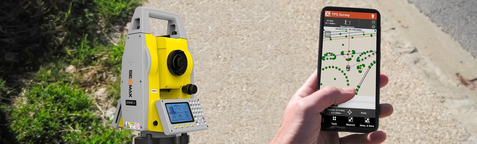
X-PAD Ultimate GO is the solution for those who need a simple and flexible field software to be used in all surveying and tracking applications with GNSS receiver and total station. Combined with our manual total station, the Zoom10, you get a user friendly and cost-effective package which operates in the most challenging work environments for the best performance and value ratio.

Hexagon Quality Control

The GeoMax software and total station portfolio have been conceived to fulfill your needs when working in the most challenging environments. Just like all the other GeoMax products, the X-PAD Ultimate GO and the Zoom10 follow the quality control of Hexagon.

Staking out points, lines, drawing cannot be simpler

X-PAD Ultimate GO runs perfectly well on most Android smartphones. You can do survey and stake out, including the addition of points, lines, arcs within the graphical view on your phone.

COGO and Reference line

X-PAD Ultimate GO includes several COGO features that help you determine new points or execute various calculations. The software also provides the Reference Line procedure, which gives you access to more information related to the current position with respect to an element chosen as reference (line, arc, drawing element).

Share and transfer: field and office, always connected

You can open and import any file, even from the cloud. Thanks to X-PAD Ultimate GO, you can save your data on the most popular cloud platforms, like Google Drive, Microsoft OneDrive and Dropbox. It is so easy to get the access to your data from the field or from your office.

More convenience and smooth workflow

The Zoom10 manual total station is a reliable solution at an affordable cost. To make your job easier, intuitive onboard software runs on two built-in displays. It ensures quick and accurate reflectorless measurement up to a range of 350m and angular accuracy of 2”.

Features

GENERAL
  • Jobs management
  • Open jobs from Gallery, Google Map and Calendar view
  • System settings (units, precision, parameters, etc.)
  • Automatic update of the application
  • Meteo info
TPS INSTRUMENTS
  • Instrument profile management
  • Support of mechanical TPS
CAD
  • Full CAD viewer
  • Display functions (zoom, pan, rotation)
  • Info commands (id, distance, area, angle, distance to object)
  • Layers management
  • Visualization of the drawing on Google Maps
MAPS
  • Several maps types available (Google, Bing, Ovi, ArchGIS, OpenStreet,…)
IMPORT/EXPORT
  • ASCII customized
  • DXF import/export, DWG import
  • LandXML
  • Esri Shape
  • Google Earth KML
  • Exchange files from cloud servers (Dropbox, Google Drive, SkyDrive)
  • Share files by e-mail, Bluetooth, Wi-Fi
  • Open files with applications installed on controller
  • Localized import/export data formats
DATA MANAGEMENT
  • Topographic points
  • Measurements
  • Features code (code - long description, symbol, layer, type)
  • Share points by e-mail, SMS, MMS
SETUP AND STATION ORIENTATION (TPS)
  • TPS orientation on reference point or reference azimuth
  • TPS orientation on multiple reference backsight points
  • Free station standard
  • Calculation of station elevation from one or multiple reference points
SURVEY
  • Standard points
  • Hidden points
  • Average of multiple measures on the same point
  • North view, direction view
  • Map view
SMART DRAWING
  • Basic drawing on measured points
STAKEOUT
  • Points (topographic points, CAD positions)
  • Lines/Arcs
  • Lines/Arcs with offset
  • Stake out reports
  • CAD drawing (lines, arcs, circles, polylines)
  • CAD drawing with offset (lines, arcs, circles, polylines)
  • North view, direction view
  • Map view
COGO & CHECK
  • Check distances from point and from lines/arcs/drawing objects
  • Intersection, alignment & offset
  • Reference line
  • Area Subdivision

Android Phone Requirements

FEATURE RECOMMENDED
Display Size 4.7” (854x480) 
CPU Quad-core 1.8Hz
RAM 3 GB
Android version  5 or higher
Architecture CPU rmeabi; armeabi-v7a x86 arm64-v8a
Connectivity Bluetooth (3 channels) WiFi

Spesification

ANGLE MEASUREMENTS 
Accuracy 2” (0.6 mgon) 
DISTANCE MEASUREMENTS 
Reflectorless Range  350m 
Kodak White reflectorless ≥350m
Reflective Sheet  800m
Single Prism 3,000m
Three Prism  6,000m
TELESCOPE
Magnification 30X
Field of View  1°20′ (2.3m at 100m)
Minimum focusing distance 1.5m
Reticle Illuminated
COMPENSATOR 
System Dual-axis
Accuracy 1″
COMMUNICATION
Interface Standard RS232, SD card, USB drive with micro USB, Bluetooth®
Internal Data Memory Approx. 20,000 points
Data Format  ASCII 
PLUMMET
Type Laser plummet, 4 brightness levels
Accuracy 1 mm at 1.5m instrument height
OPERATION
Keyboard 2 sides alphanumeric backlit rubber keyboard
Display High resolution backlight black and white display with contrast adjustment Graphics: 280 x 160 pixels Character: 6 lines x 25 characters
Data recording 1 GB internal memory, removable SD card and USB stick
Operating system Dedicated onboard software
PHYSICAL SPECIFICATIONS
Operating / storage temperature -20° C to 50° C / -40° C to 70° C
Protection class IP54 dust and waterproof rating
Power supply 
Internal battery ZBA10, removable Li-Ion 3 Ah / 7.4 V
Operating time 10-16 h*

Download Katalog

Download Brochure